CDS specializes in commercial drone photography in SC. CDS provides state-of-the-art drone photography and video services. As leaders in advanced drone technology, we specialize in capturing stunning aerial images and videos that transform perspectives and elevate your projects to new heights. Whether you’re documenting job sites, surveying construction progress, showcasing properties for real estate, or inspecting roofs and houses, our high-definition drone photography ensures precision, clarity, and a bird’s-eye view like no other drone on the market.
At Conservation Drone Services, we pride ourselves on delivering top-notch visual content tailored to meet your unique needs. Our team of skilled pilots and cutting-edge drones work in harmony to provide detailed, high-resolution images that offer invaluable insights and breathtaking visuals. Join us as we explore in detail how our innovative drone solutions can enhance your projects and bring a fresh perspective to your endeavors.
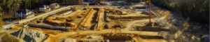
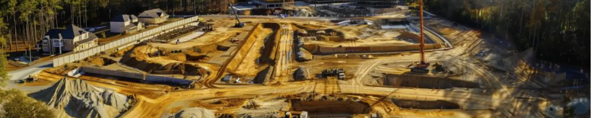
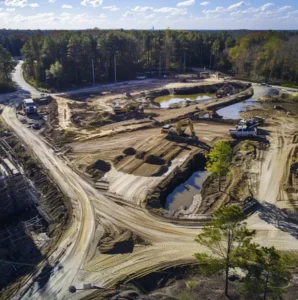
Surveying Construction Progress on Job Sites
An aerial drone can document job sites and survey construction progress in several effective and innovative ways:
- High-Resolution Imagery and Video
Drones equipped with high-definition cameras can capture detailed images and videos of construction sites. This visual data provides a comprehensive overview of the project’s status, allowing stakeholders to monitor progress and identify any potential issues from a unique aerial perspective.
- Regular Progress Monitoring
By conducting regular drone flights, construction managers can maintain a consistent and up-to-date record of the site’s progress. These images and videos can be compared over time to track the advancement of different phases, ensuring that the project stays on schedule.
- Accurate Measurements and Mapping
Drones can create precise maps and 3D models of construction sites using photogrammetry and LiDAR technology. These tools enable accurate measurement of distances, areas, and volumes, which are crucial for planning and verifying construction tasks.
- Enhanced Safety Inspections
Using drones to inspect hard-to-reach or hazardous areas reduces the risk to human inspectors. Drones can safely navigate high elevations, confined spaces, and unstable structures, capturing detailed data without putting personnel in danger.
- Real-Time Data Sharing
Drones equipped with real-time video streaming capabilities allow construction managers to observe the site remotely. This feature facilitates immediate decision-making and coordination, especially beneficial for large or geographically dispersed projects.
- Improved Communication
High-quality aerial visuals help improve communication among project teams, clients, and stakeholders. These images provide a clear and comprehensive understanding of the site, making it easier to discuss progress, challenges, and next steps.
- Documentation for Compliance and Reporting
Drones can document every stage of construction, creating an invaluable archive of the project’s development. This documentation can be used for compliance with regulatory requirements, quality assurance, and reporting to investors or clients.
- Marketing and Presentation
Aerial drone footage enhances the visual appeal of presentations and marketing materials. Construction companies can showcase their capabilities and completed projects with captivating aerial shots, attracting new clients and investors.
By leveraging the advanced capabilities of drones, Conservation Drone Services ensures that construction sites are meticulously documented and surveyed, providing essential data and insights that drive efficiency, safety, and project success.
 12 Ways Businesses in SC Benefit from Aerial Drone Photography?
Businesses across various industries are leveraging aerial drone photography in numerous valuable ways all across the world. Us at Conservation Drone Services are the leader in using Drone Photography in South Carolina. Here are some of the most impactful applications that businesses all across the state can use:
- Construction Site Monitoring
Drones offer real-time monitoring of construction progress, allowing project managers to track the development of projects efficiently. Regular drone flights provide updates, ensure projects stay on schedule, and most importantly identify potential issues early on.
- Real Estate Marketing
Aerial drone photography provides stunning visuals that highlight the unique features of properties. High-resolution images and videos showcase large estates, commercial properties, and residential developments from an appealing aerial perspective, attracting potential buyers and investors.
- Agricultural Management
In agriculture, drones are used for crop monitoring, irrigation management, and assessing field conditions. Aerial imagery helps farmers detect plant health issues, optimize irrigation, and improve overall crop yields.
- Infrastructure Inspection
Aerial drones inspect critical infrastructure such as bridges, power lines, wind turbines, and pipelines. They provide detailed visual data while reducing the need for manual inspections in dangerous or hard-to-reach areas, improving safety and efficiency overall.
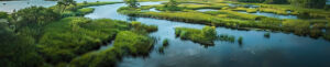
- Environmental Conservation
Conservation organizations use drones to monitor wildlife, track deforestation, and assess environmental damage. Aerial photography aids in mapping habitats, observing animal populations, and supporting conservation efforts with precise data.
- Disaster Response and Management
Drones are invaluable in disaster response, providing rapid assessment of affected areas after natural disasters like floods, hurricanes, and earthquakes. They help emergency responders plan and execute rescue operations more effectively.
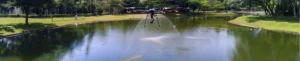
- Event Coverage
Drones capture spectacular aerial views of large events such as concerts, festivals, and sports events. The unique vantage point enhances media coverage and provides engaging content for promotional materials.
- Surveying and Mapping
Surveying and mapping industries use drones for creating accurate topographical maps, 3D models, and land surveys. Drones offer a quicker, safer, and more cost-effective solution compared to traditional ground survey methods.
- Marketing and Advertising
Businesses use aerial drone photography to create captivating marketing content. Stunning aerial shots and videos enhance websites, social media campaigns, and promotional materials, making brands stand out and engage audiences effectively.
- Land and Property Development
Developers utilize drone photography for site selection, planning, and progress tracking. Aerial views provide a comprehensive understanding of the land, helping in the design and layout of new developments and infrastructure projects.
- Insurance Assessments
Insurance companies use drones to assess damage after incidents like fires, storms, and accidents. Aerial imagery enables quick and accurate damage evaluations, speeding up the claims process and improving customer satisfaction.
- Tourism and Travel
Tourism businesses use drone photography to showcase destinations, resorts, and attractions from unique angles. Aerial visuals attract tourists by highlighting scenic landscapes, landmarks, and experiences available at various locations. In South Carolina specifically, Conservation Drone Services provide the best quality drone photography for areas like Charleston, Myrtle Beach, Greenville, Columbia, and more.
In the progressive business landscape, integrating aerial drone photography into operations is no longer a luxury but a necessity. As highlighted throughout this article, the applications of drone technology offer unmatched benefits across various industries. From real estate to construction, agriculture to environmental conservation, and beyond, the advantages of high-resolution aerial photography provide such beautiful results.
At Conservation Drone Services, we are committed to delivering top-tier drone photography in South Carolina that transforms how businesses visualize and manage their projects. Our advanced drone technology provides detailed, accurate, and breathtaking visuals that enhance efficiency, improve safety, and boost marketing efforts. By capturing the world from a birds eye view, we help businesses gain new insights, make informed decisions, and showcase their work in the most progressive way possible.
Embrace the future of visual documentation with Conservation Drone Services and experience the transformative power of aerial drone photography in South Carolina. Enhance your business operations, stay ahead of the competition, and let us help you see the bigger picture from a whole new perspective.
Give us a call at 843.833.0771 or email us at [email protected].